

Guide NaviBoss help
How to use a VRM and EBL on the chart
Put a range ring with a bearing line on the chart, as on radar, and read or type its range and bearing from any point you choose.
VRM draws a range ring round a point you choose, with a bearing line (EBL) from the centre to the ring, as on your radar. Its label reads, for example, VRM 1 · 48.1 nm · 052.7°. The VRM button is the ring under Line, at the top right of the chart. You can have as many VRMs as you like.
#Set a VRM
Press VRM
The button lights up and the pill at the top of the chart says Click a centre point.
Click the centre
The ring and the bearing line now follow the pointer.
Click to set the range
The second click sets the range and the bearing. The label shows both.
You can also right-click the chart and choose VRM here. On a phone, press the measure button in the capsule at the top and choose VRM, then tap the centre and tap again for the range.
#Type a range and bearing
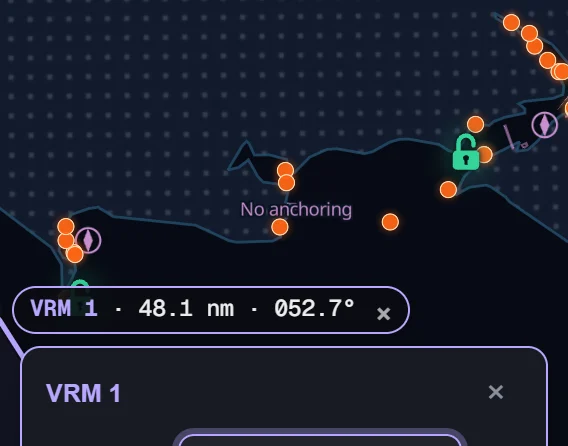
Click the label
The VRM's card opens.
Type the Range and the Bearing
Range is in nm (or km, by Settings), up to 3,000 nm. Bearing is in degrees true. The ring follows as you type.
Press Done
Under the boxes the card shows the centre's position in your coordinate format.
#Move or delete a VRM
- Move it: drag the centre. The whole ring goes with it.
- Change the range: drag the point where the bearing line meets the ring.
- Delete it: press the small × on its label, or Delete in its card. Undo shows for a few seconds (Ctrl + Z works too).
#Why a big ring looks stretched
The ring is true distance: every point on it is the same number of miles from the centre. On the flat chart a big ring far from the equator therefore looks like an egg, longer towards the pole. Under about 200 nm it looks round.
When a ring is stretched, its label says Stretched by the flat chart · see it round ›. Press it and NaviBoss turns the globe on and shows the ring round. The bearing line follows the great circle, so it leaves the centre on the bearing its label shows.
About our guides
NaviBoss guides are written and checked by maritime industry experts, masters and deck officers. Each one is built from the same data the planner uses, dated, and rebuilt when that data changes. Spotted something wrong? Tell us on the feedback board.
A planning aid, not for navigation. Check official charts and publications, the latest notices and your company's instructions before you rely on any figure here.
Free Ready when you are
Try VRM on your own chart
Free account, no card. It is on the planner's chart.
Open the plannerFree account · no card