

Security briefing · for officers, masters and shore teams
Piracy map, October 2026
As of 8 Oct 2026 there are 4 ITF/IBF warlike areas and 4 JWC listed areas at sea, and the piracy hotspots in the ICC-IMB and ReCAAP reports are the Gulf of Guinea and the Singapore & Malacca Straits. The old Indian Ocean High Risk Area was withdrawn on 1 January 2023.
Bound for the Red Sea, the Gulf of Aden or the Gulf? Read the table before you sign the passage plan. The warlike rows are the ones that touch your pay: on a ship covered by an ITF or IBF agreement, that list is what triggers the bonus and the right to refuse. The JWC rows are the owner's insurance. The reporting areas tell you who to call.
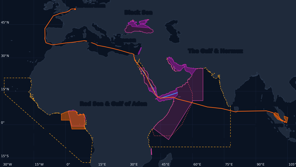
- ITF/IBF warlike area
- JWC listed area
- Piracy hotspot
- Reporting area
- Transit corridor
- Former High Risk Area (withdrawn)
- Rotterdam → Singapore via Suez
The 17 areas, with their dates
| Area | Type | Set by | In force since | Incidents, 30 days | Source |
|---|---|---|---|---|---|
| Southern Red Sea & Gulf of Aden | ITF/IBF warlike area | ITF and IBF (crew agreements) | 19 Mar 2024 | — | ITF/IBF warlike list (1 Oct 2026) |
| Northern Black Sea & Sea of Azov | ITF/IBF warlike area | ITF and IBF (crew agreements) | 1 Mar 2022 | — | ITF/IBF warlike list (1 Oct 2026) |
| Persian Gulf, Strait of Hormuz & Gulf of Oman | ITF/IBF warlike area | ITF and IBF (crew agreements) | 6 Mar 2026 | — | ITF/IBF warlike list (1 Oct 2026) |
| Israel & Lebanon (extended risk zone) | ITF/IBF warlike area | ITF and IBF (crew agreements) | 13 Mar 2026 | — | ITF/IBF warlike list (1 Oct 2026) |
| Persian Gulf, Arabian Sea & southern Red Sea | JWC listed area | Lloyd's Joint War Committee (insurers) | 29 Jul 2026 | — | JWC JWLA-035 |
| Black Sea & Sea of Azov | JWC listed area | Lloyd's Joint War Committee (insurers) | 16 Sep 2026 | — | JWC JWLA-035 |
| Gulf of Guinea | JWC listed area | Lloyd's Joint War Committee (insurers) | 3 Mar 2026 | — | JWC JWLA-035 |
| Cabo Delgado, Mozambique | JWC listed area | Lloyd's Joint War Committee (insurers) | 3 Mar 2026 | — | JWC JWLA-035 |
| Gulf of Guinea | Piracy hotspot | Drawn by NaviBoss from ICC-IMB and ReCAAP reports | Ongoing (from reports) | — | ICC-IMB reports (approximate) |
| Singapore & Malacca Straits | Piracy hotspot | Drawn by NaviBoss from ICC-IMB and ReCAAP reports | Ongoing (from reports) | — | ReCAAP / ICC-IMB reports (approximate) |
| Red Sea, Gulf of Aden, the Gulf & western Indian Ocean | Voluntary reporting area | UKMTO | 23 Oct 2025 | — | UKHO Q6099 ed.11 |
| West Africa (Gulf of Guinea and approaches) | Voluntary reporting area | MDAT-GoG | — | — | UKHO Q6114 / MDAT-GoG |
| IRTC, Gulf of Aden | Transit corridor | UKMTO chart Q6099 | 23 Oct 2025 | — | UKHO Q6099 ed.11 |
| Yemeni Northern Route, Red Sea | Transit corridor | UKMTO chart Q6099 | 23 Oct 2025 | — | UKHO Q6099 ed.11 |
| Yemeni Southern Route, Bab el-Mandeb | Transit corridor | UKMTO chart Q6099 | 23 Oct 2025 | — | UKHO Q6099 ed.11 |
| Yemeni Waiting Area | Transit corridor | UKMTO chart Q6099 | 23 Oct 2025 | — | UKHO Q6099 ed.11 |
| Somali Basin & Gulf of Aden | Former High Risk Area | Shipping industry (BMP5) | 1 May 2019 Withdrawn 1 Jan 2023 | — | BMP5 High Risk Area (2019; withdrawn 2023) |
Incidents: the reports could not be read when this page was built. The ITF/IBF designations follow the list of 1 Oct 2026. That list is reissued every few weeks and each designation carries an end date, so check the current list before you rely on a date. The piracy hotspots are approximate, drawn from where the reports cluster.
What it means on real voyages
Worked out by NaviBoss's own router on real shipping lanes, the same answer the planner gives. Rotterdam → Singapore via Suez is 8,414 nm and passes through 8 of these areas. Going round the Cape clears the Red Sea and the Gulf of Aden, at a price in miles. No route here is sent through the Arctic.
| Voyage | Distance | Miles inside each area |
|---|---|---|
| Rotterdam → Singaporevia Suez | 8,414 nm |
|
| Rotterdam → Singaporevia the Cape of Good Hope (Suez avoided) | 11,905 nm (+3,491 nm) |
|
| Jebel Ali → Singaporeout through Hormuz | 3,508 nm |
|
| Cebu → Houstonvia Suez (Panama avoided) | 13,151 nm |
|
| Cebu → Houstonvia the Cape (Panama and Suez avoided) | 14,323 nm (+1,172 nm) | Crosses none of these areas. |
Four lists that get mixed up
- ITF/IBF warlike areas
- Set by the unions and employers who sign the crew agreements. They change what the crew gets: extra pay for the days inside, and in a warlike area the right to refuse to sail. The amounts are in your CBA or contract.
- JWC listed areas
- Set by the Joint War Committee of the London insurance market. They change the owner's insurance: entering one can need extra war-risk cover. They say nothing about crew pay.
- Reporting areas
- The UKMTO Voluntary Reporting Area (Red Sea, Gulf of Aden, the Gulf and the western Indian Ocean) and the MDAT-GoG area off West Africa. Inside them, ships are asked to register and report their position. Reporting, not risk.
- The former High Risk Area
- The BMP5 High Risk Area off Somalia and in the Gulf of Aden was withdrawn on 1 January 2023. People still search for it, so the map shows it dashed, for reference. It no longer applies.
Questions seafarers ask
Is the Gulf of Aden still a High Risk Area?
No. The shipping industry withdrew the Indian Ocean High Risk Area on 1 January 2023. The Gulf of Aden is now inside the Southern Red Sea & Gulf of Aden ITF/IBF warlike area (in force since 19 Mar 2024) and the Persian Gulf, Arabian Sea & southern Red Sea JWC listed area, and inside the UKMTO Voluntary Reporting Area, where ships are asked to report.
Is the Red Sea safe for shipping right now?
Nobody can promise that, and this page does not try. The southern Red Sea and Gulf of Aden have been an ITF/IBF warlike area since 19 Mar 2024. The latest incidents there are counted in the "What changed" box at the top of this page. Before a transit, read the latest UKMTO and MSCIO advisories and your company's instructions. The decision stays with the master and the company.
Where are the piracy hotspots now?
In the Gulf of Guinea and the Singapore & Malacca Straits. These areas are drawn by NaviBoss from the ICC-IMB and ReCAAP reports, so they are approximate. ICC-IMB's live piracy map and ReCAAP's reports give each incident.
Where must I report to UKMTO?
Inside the UKMTO Voluntary Reporting Area, which covers the Red Sea, the Gulf of Aden, the Gulf and the western Indian Ocean (the amber dashed area on the map). Ships are asked to register with UKMTO on entering it and to send daily position reports. Off West Africa the same job is done by MDAT-GoG, in its own reporting area.
Is the Strait of Hormuz a warlike area?
Yes. The Persian Gulf, Strait of Hormuz & Gulf of Oman has been an ITF/IBF warlike area since 6 Mar 2026, on the list of 1 Oct 2026. The ITF/IBF list is reissued every few weeks, and each designation has an end date, so check the current list and your CBA.
How many miles of my route are inside these areas?
It depends on the route. Rotterdam → Singapore via Suez is 8,414 nm, of which 775 nm are inside an ITF/IBF warlike area and 1,910 nm inside a JWC listed area. Going via the Cape of Good Hope is 11,905 nm, 3,491 nm longer, and crosses neither. Plan your own voyage in NaviBoss's Piracy & security tool to get the miles inside each area.
Can I navigate by this map?
No. It is a planning aid, not for navigation. The areas are drawn from the published documents named on this page, and the piracy hotspots are approximate. Always check the official sources, your company's instructions and your contract.
Your own voyage, mile by mile
Enter two ports in NaviBoss and the Piracy & security tool lists every area the route crosses, with the miles inside each and the latest incidents near it. Free with an account.
Check your own route against these zones →Sources and method
Every area is drawn from the published document named in its row. NaviBoss checks those documents every week and redraws an area when its source changes; the last check was on . The miles come from NaviBoss's router on its lane network, measured inside each area. Incidents come from the public reports of the centres listed below.
- ITF/IBF list of warlike and high-risk areas
- Lloyd's Joint War Committee, JWLA-035
- UKMTO chart Q6099, edition 11
- MSCIO voluntary reporting guidance (Indian Ocean and Red Sea)
- MDAT-GoG reporting area (BMP Annex B, via MSCIO)
- BMP Maritime Security (successor to BMP5)
- ICC International Maritime Bureau, Piracy Reporting Centre
- ReCAAP Information Sharing Centre
- UKMTO recent incidents
- MSCIO alerts
About our guides
NaviBoss guides are written and checked by maritime industry experts, masters and deck officers. Each one is built from the same data the planner uses, dated, and rebuilt when that data changes. Spotted something wrong? Tell us on the feedback board.
A planning aid, not for navigation. Before a transit, check the latest UKMTO and MSCIO advisories, the official in-force lists, your company's instructions and your contract.